
Explore Your Watershed
This resource supports educators to explore watersheds with students in classroom and outdoor settings. This learning resources was piloted in partnership with the University of Iowa's School of the Wild.
Activity Overview
This activity, designed for upper elementary to middle school students, requires 4-5 hours of instructional time.
Students will explore their local watershed to understand how human activity affects it and vice versa. They will begin by discussing personal experiences with water, floods, and their communities' flood history. This will lead to questions about water movement, flood causes, and mitigation strategies.
Next, students will examine maps of their local area, including parks or schoolyards, to identify landforms and land cover. They will then investigate a wetland, considering human impact and the surrounding landscape’s role. Finally, students will create a watershed model to synthesize their findings and reflect on how watershed health influences local flooding and community decisions.
Guiding Questions
- What is a watershed?
- What is our watershed made of?
- How do we impact our watershed and how does our watershed impact us?
- How can we help protect our watershed?
Iowa State Standards Connections
Science - 5-ESS3-1. Obtain and combine information about ways individual communities use science ideas to protect the Earth’s resources and environment.
Science and Engineering Practice – Developing and using models.
Cross-Cutting Concepts – Systems and system models.
Social Studies - SS.5.19. Create geographic representations to illustrate how cultural and environmental characteristics of a region impacted a historical event.
Literacy – SL.5.2. Summarize a written text read aloud or information presented in diverse media and formats, including visually, quantitatively, and orally.
Universal Constructs – Critical thinking while examining issues that develop innovative responses – Collaboration toward productive group interactions and respectful disagreement.
Explore Your Watershed Activity
Our Water Stories
Eliciting Background Knowledge
Begin by activating student background information by asking students to interview a partner, asking the following questions.
Have you ever seen or explored a lake, pond, river or stream? Tell me what you noticed.
Where have you seen water go when it rains?
Have you ever heard of or seen a flood happen? What happened?
Once each student has had a chance to interview and be interviewed. Ask students to share out about what their partners said. Highlight any similarities or differences you notice in students’ ideas and experiences.
Anchoring Phenomenon: A Local Flood Event
Next, share with students about a local flood event you have discovered. Have student pairs take time to read about, look at photos of and consider data about this flood event. Ask to discuss what they notice about what happened and what they wonder about the flood event. After students have looked at data and photos, ask them to share what they think caused the flood event to happen. Encourage students to refer to the data to support their thinking. See the data resources section below to find a relevant flood event.
Surveying the Land
Examining Maps
Distribute all maps and ask students to share what they are noticing about each map by writing observations in their journal. Ask students what maps would help them identify where they are.
Topographic Map – Help students understand the topographic map using your hand or a willing student’s hand to draw topographic lines. By making a fist and then flattening your hand, you can demonstrate how each line on the maps represents different elevations on the land.
Hybrid Imagery Map – Ask students to share what type of land uses they are seeing on this map. How is the park different from areas around the park? How is it different from their school and neighborhood?
Landcover Map – Share with students that each color on the map represents a different type of landcover but there is a problem with this map, it does not have a legend. Ask students how they might create their own legend for this map.
LiDAR Map – Explain to students that LiDAR is a technology that helps us map the surface of Earth. This map helps show us topography throughout the park
Land Survey Walk
In this section you will lead students on a walk you have planned. Ask the group to stop along the way to ask students to discuss and/or document the following:
- Describe the land here.
- What landcover are we hiking through? Can we see other types of landcover around us? Ask students to compare what they are seeing to their maps.
- If it were raining right now where might raindrops accumulating here end up? (water could infiltrate into the ground, run-off across the land, or might be used by plants in the area). Use the LiDAR map and Topographic map for students to explain their thinking.
- What does the soil look like here? Take a few minutes to test water infiltration on an area (see below).
- What else are we observing in this location? If students find wildlife they want to observe, that is great! Take the time to stop and allow students to discuss all observations.
Water Infiltration Test Procedure
- Place your cylinder into the ground firmly ensuring there are no open spaces between the cylinder and ground where water may escape.
- Calculate how much liquid is needed to demonstrate a 1inch rain event on the space. For a cylinder with a diameter of 6 inches – use about 16 ounces of water.
- Pour the measured volume of water onto the ground in the space marked by the cylinder.
- Use a watch or cellphone to time how long it takes the water to “infiltrate” or soak into the ground.
Exploring Wetland Environments
Tell students that they will explore the environment three times, looking for evidence of something new each time they go back to explore the space.
Evidence of Humans
What do you notice about this environment that might have been created by people? Did people leave anything here?
Give students 10 minutes to observe the area and record what they find in their journals. Then, bring everyone together to discuss.
Note: In some places the wetland itself might have been created by people. If you can, find out the history of the wetland you are exploring ahead of time and share this with students after this section.
Nonliving Elements of the Environment
What nonliving things make up this environment?
Give students 10-15 minutes to look for nonliving components of the environment. They might identify the water, rocks and soils, etc. Ask students to be specific about what they are finding. Are all the rocks the same? Are there different types of dirt/soil/sediment? Encourage students to record what they are finding in their journal.
Once students have explored, come back together and ask them to consider how they might learn more about these nonliving things. If you have them, introduce tools such as a turbidity tube, thermometer, and magnifying glasses to help students collect more information about each component they identified. Consider conducting another water infiltration test near the water.
Living Things in this Environment
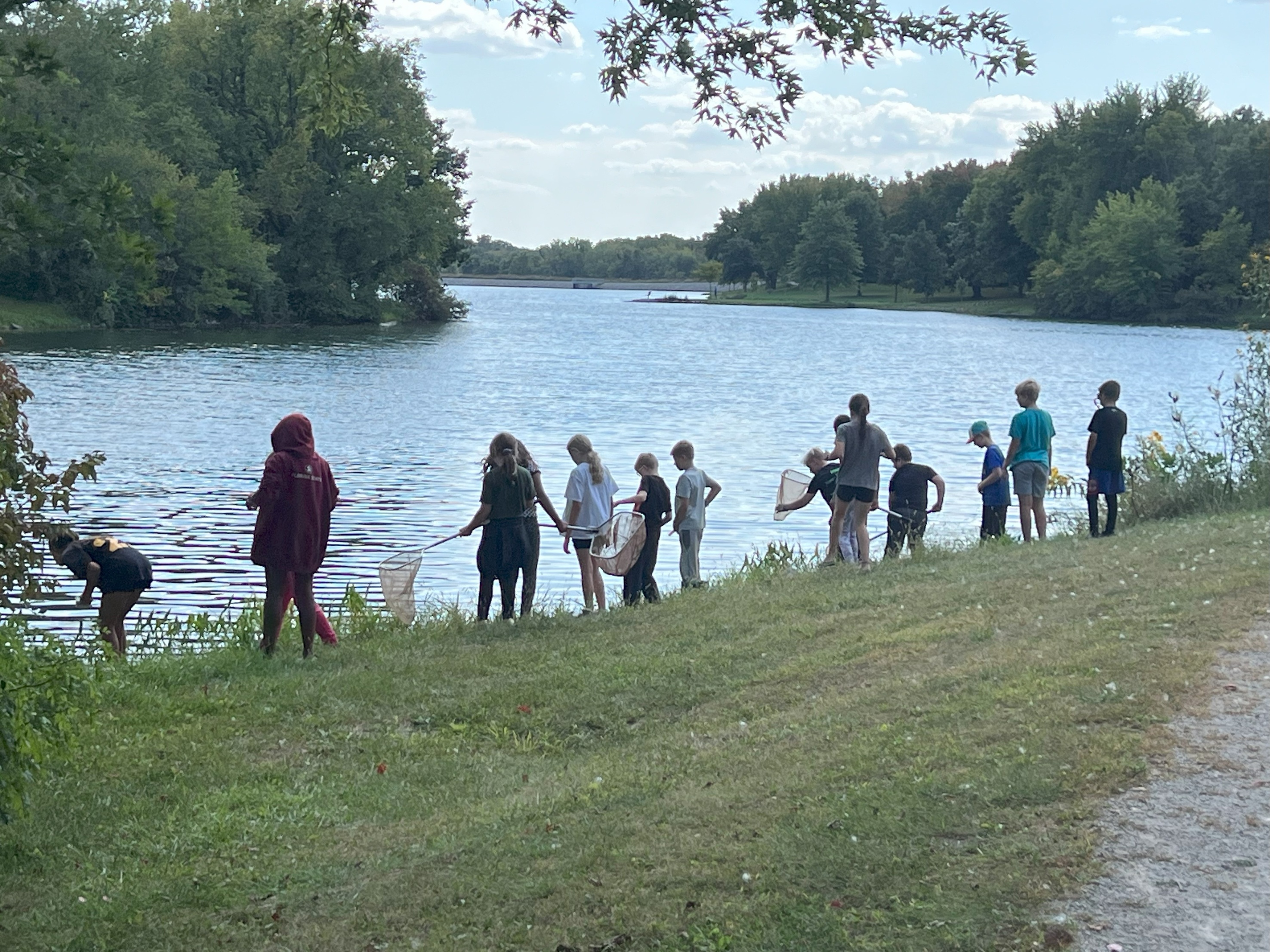
Students can next work together to explore the environment looking for living things and evidence of living things. Some examples of evidence of living things in a wetland might include trees or tree stumps that beavers have chewed on, bubbles on the surface of the water, animal scat, etc. Use wetland field guides, nets, and buckets to aid exploration if possible.
Give students about 30 minutes to look for living things and evidence of living things in the environment. Encourage students to record what they are finding in their journal.
Once students have explored come back together and ask students to share what they found while exploring and discuss whether they think this is a healthy wetland. Ask student to use evidence from their exploration to support their ideas about the health of the wetland.
Reflecting on Explorations
Ask students to begin to make connections between their land survey and wetlands exploration.
Consider asking the following questions:
Where might the water go if it didn’t soak (infiltrate) into the ground?
What might the water carry with it? Did we find any evidence of this while exploring this wetland?
What might happen to the land and to this wetland if we get lots of rain?
Modeling a Watershed
Keep students in pairs, or for larger groups (more than 12) have students work in groups of 3 or 4.
Each group will need a piece of paper or cardstock and a blue marker. Instruct each group to:
- Crumple their paper into a ball.
- Gently partly uncrumple their paper. Do not completely smooth the paper out.
- Tell students that their paper represents a landscape, to imagine they are looking down at this landscape as if they are a bird flying above it. Ask students to identify different landforms. If needed, introduce the terms: ridgeline and ravine.
- Instruct students to use their blue marker to trace all the ridgelines or the highest parts of their paper landscape.
- Tell the students that it is going to rain on their landscapes. Walk to each group and spray their landscape with your spray bottle so that the blue begins to run across the paper. Do not spray so much that the paper is soaked through and cannot hold its shape!
- Ask students to make observations about how the water is running across the paper landscape. Use the following questions to discuss:
- Where is the water going? What types of waterways are you seeing begin to form?
- Is all the water ending up in the same place or is it going to separate places?
- Can you define areas where all the water is going to the same low point? These are your watersheds!
- Explain to students that this is a model of a watershed. We use models to better understand large systems that can be hard to see all at once. Ask students to think about how the model is like the land and water they explored, and how it is different (what are the limitations of the model?).
Welcome to your Watershed!
Option 1: Create an “interpretive sign” for the park that explains to visitors what a watershed is and why it is important to protect.
Provide students with examples of local interpretive signs on other topics. Note them if you pass any while exploring your local park.
Suggest that students might include:
- A diagrammatic model (drawn picture) of the watershed, identifying the name of the watershed if possible.
- A description of the watershed:
- What is the topography like?
- What streams, pond, lakes, or rivers are in the watershed?
- What is the land cover made of in the watershed?
- Why do we need to protect this watershed? What can people do to help protect this watershed?
Option 2: Design a solution to a real or hypothetical flood problem. Use observation from the land survey to identify a problem such as water pooling somewhere on the school grounds or go back to students’ models and identify a flood-prone area in their model.
Additional Resources
Educator Background Information
What is a Watershed?
A watershed is an area of land that drains into a lake or river. As rainwater and melting snow run downhill, they carry sediment and other materials into our streams, lakes, wetlands and ground water.
Watersheds are organized into different sizes using a classification system called HUC (Hydrologic Unit Code). Smaller watersheds (HUC 8s or HUC 12s) make up larger watersheds (HUC 2s). For example, Iowa City is located in the Ralston Creek (HUC12), Lower Iowa (HUC 8), Upper Mississippi Region (HUC 2). Click this link to find your watershed.
We all live in a watershed. It is important to understand how the decisions of upstream communities impact those downstream when making decisions about water ways, land use, and infrastructure.
Iowa’s Watersheds
Land Use
Land use in a watershed can impact the health of the watershed. In Iowa, which is dominated by agricultural land uses including row cropping and raising livestock, waterways can be impacted by erosion of bare fields transporting sediment into waterways, agricultural chemicals being transported with precipitation into the water. Additionally, people have also changed the shape of rivers and streams through a process called stream channelization to create more farmland or safer passageways to transport goods on rivers. This process can disrupt the watershed by changing the rate at which water moves and the habitat around waterways.
Urban areas also impact watersheds where heavily built environments with concrete can cause more water run-off. Concrete can also heat water, causing a disruption to fish and other aquatic wildlife that require colder water in streams.
Management
Water resource professionals work across Iowa to protect and manage the state’s watersheds. These professionals monitor water quality, collect data on stream and river levels, engineer and implement flood mitigation practices, and much more. These professionals as well as city and county officials and other local leaders have formed watershed management groups across the state. These groups work together to create management plans for their watershed and secure funding to complete watershed projects such as restoring stream banks that have been eroded, restoring wetlands, building urban stormwater run-off practices such as permeable pavement and bioswales and
Preparing Learning Materials
Prepare Maps (Before Teaching)
Prepare maps for the area you will be studying. This might be your school grounds or a nearby local park. Follow the directions below to get maps for this lesson.
Go to the Iowa Geographic Map Server (Click Here).
Search for your local park.
Take screenshots of the map with the following specifications:
Basemap: Hybrid Imagery Content: none
Basemap: Hybrid Imagery Content: Iowa – 2002 DNR Land Cover
Basemap: Hybrid Imagery Content: Iowa - 2020 – LiDAR Hillshade
Basemap: Topographic Content: Iowa - 2020 – LiDAR Contours
Materials List
Our Water Stories
|
Surveying the Land
|
Exploring a Wetland Environment
|
Watershed Modeling
|
Welcome to Your Watershed!
|
