
The Texas Hill Country along the Guadalupe River is a beautiful area of rolling hills, steep limestone canyons, thin topsoil, and pristine, clear water. This landscape brings visitors who are drawn to the region’s natural beauty and open spaces.

In the hours after midnight on July 4, 2025, the remnants of Tropical Storm Barry brought torrential rainfall to the area. The system stalled over south Texas and dropped 5 to 11 inches of rain in just a few hours. The precipitation fell on rock hard, drought-impacted soil that was unable to absorb much of the runoff.
The Guadalupe River, notorious for frequent flash flooding, rose 37 feet in 45 minutes.
Most of the visitors, campers, and residents were fast asleep as the disaster unfolded. The water swept away homes, cars, businesses, and cabins, leaving behind a ravaged landscape and taking 139 lives.
It was the sixth-deadliest freshwater flood on record in the United States.
A Case Study

Felipe Quintero, an associate research scientist at the Iowa Flood Center (IFC) at the University of Iowa, is part of a research team that is analyzing the Texas Hill Country flood event and taking on the challenge of providing accurate, timely flash flood forecasts.
The 2025 Texas flood event was not a one-off, once-in-a-lifetime disaster, Quintero says.
“It’s going to happen again,” he says. “And maybe, it’s going to be worse.” — Felipe Quintero
The research team includes Quintero’s fellow IFC researchers Witold Krajewski (former IFC director and co-founder), Humberto Vergara, and Yagmur Darin, along with James Smith at Princeton University, Bong-Chul Seo at Missouri University of Science and Technology, and Alejandro Buil at Meteoclim in Spain. Together, they are exploring ways of producing timely flash flood forecasts that are accurate enough to deliver an early warning and potentially save lives.
Forecast Options
Flash flooding is not a new problem, but it is intensifying and becoming more frequent due to global warming. Finding a solution that can save lives is more urgent than ever, Quintero says.
“Forecasting — it’s difficult everywhere, but it’s especially difficult in these small basins where there is so little time to provide a warning,” he adds.
Quintero is hoping to learn if a different forecasting method could have helped in this case.
The team explored two rainfall forecasting options for the Texas case study, he says. Federal agencies use the first option, which relies on complex numerical weather prediction models that resolve the physics of the atmosphere. With this method, forecasters can estimate projected rainfall for the next 18 hours.
This method has pros and cons, Quintero explains. Because the physics problem is difficult and data are scarce, the model often performs poorly during the first few hours.
“Then the models start to warm up and they behave better,” Quintero says. Still, he adds, it typically fails to put rainfall in the right place.
Right Place, Right Time
The second approach, radar extrapolation, is less sophisticated but more pragmatic. Radar extrapolation does not model the atmosphere, but rather predicts where observed radar rainfall will move in the next couple of hours.
Forecasters use radar extrapolation to estimate the motion field of the rainfall based on the latest observations. “We just move the rain in that direction,” Quintero says. This way, they can forecast the rainfall for the next one or two hours.
Although it has weaknesses, this method looks at an area in more detail and is better able to put the rainfall in the right place.
“That for me is the more important component,” Quintero says. “It’s about getting something — even though it’s not completely accurate — but having a forecast out there with enough time to react.”
Buying Time
Many things need to happen after a forecast is issued before it becomes helpful to end users. Emergency managers need to receive the communication and adjust it. They need time to go back to the plans they already have in place and create a strategy to cope with the emergency.
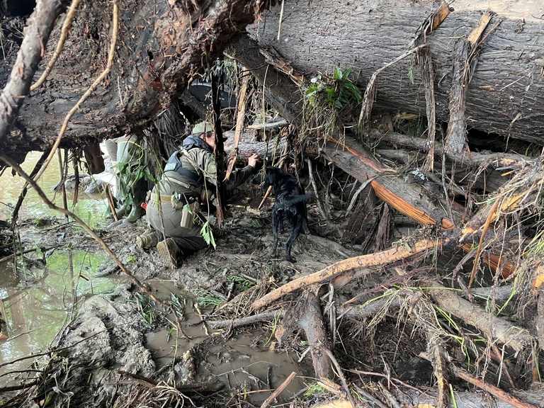
“So, all that time that we are buying in the hydrological first forecast is time that the emergency managers can use to take preventive measures,” Quintero says.
As extreme weather events become more intense and more frequent, forecasters and emergency managers are finding ways to adjust. “I think that it’s about adapting to that new reality and being prepared and exploiting the available technology to save lives,” Quintero says.
Iowa Flood Center
Iowans experience intense rainstorms, and some areas of the state are prone to flash flooding. The 2024 flood in northwest Iowa is an example, although it wasn’t a flash flood, Quintero says. “It was a very heavy flood, and it had a lot of impact.”
But there is one big difference in Iowa.
“We have the Iowa Flood Center,” Quintero says. “Iowans know that there is a tool out there — the Iowa Flood Information System — that they can check anytime, and it’s very easy to understand. So, they are more aware of what’s going on and what could happen in the short term.”
He adds, “I think that we are moving in the right direction and we will continue to improve our tools to help Iowans.”